500k North Walsham - Clacton
Located in United Kingdom
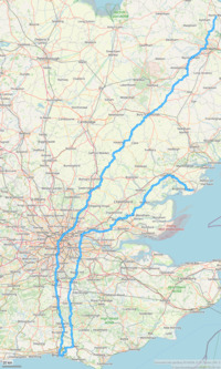
A one-day challenge going from North Norfolk to Essex, via the Sussex south coast. On the way down we cross the Thames on Chelsea Bridge, and on the way up we use the Woolwich foot tunnel. The route is mostly on smaller roads, but some lengths of A road are needed in places.
Surface type: 100% road
Traffic levels: 85% Quiet roads 15% Busy / main roads
502km long 4585 metres of climbing 35hrs59 at 13.9kmh-
Wymondham This is a town/village 37 km from start 42m above sea level 2hrs36 at 14.3kmh

-
Bury St Edmunds This is a town/village 88 km from start 37m above sea level 6hrs08 at 14.3kmh

-
Steeple Bumpstead This is a town/village 123 km from start 61m above sea level 8hrs39 at 14.2kmh

-
Epping This is a town/village 177 km from start 111m above sea level 12hrs33 at 14.1kmh

-
Chelsea Bridge This is a monument 211 km from start 5m above sea level 14hrs50 at 14.2kmh

-
Redhill This is a town/village 241 km from start 81m above sea level 17hrs06 at 14.1kmh

-
Haywards Heath This is a town/village 272 km from start 74m above sea level 19hrs19 at 14.1kmh

-
Ditchling Beacon This is a start of climb 282 km from start 73m above sea level 20hrs03 at 14.0kmh https://www.strava.com/segments/770191

-
Ditchling Beacon This is a viewpoint 284 km from start 217m above sea level 20hrs18 at 14.0kmh

-
Brighton This is a town/village 295 km from start 12m above sea level 21hrs03 at 14.0kmh

-
East Grinstead This is a town/village 338 km from start 135m above sea level 24hrs18 at 13.9kmh

-
Chalkpit climb This is a start of climb 358 km from start 114m above sea level 25hrs42 at 13.9kmh https://www.strava.com/segments/16291169

-
Oxted Ridge This is a viewpoint 360 km from start 248m above sea level 25hrs56 at 13.9kmh

-
Biggin Hill This is a town/village 367 km from start 183m above sea level 26hrs28 at 13.9kmh

-
Woolwich This is a town/village 389 km from start 28hrs03 at 13.9kmh

-
Upminster This is a town/village 410 km from start 23m above sea level 29hrs27 at 13.9kmh

-
Billericay This is a town/village 427 km from start 87m above sea level 30hrs43 at 13.9kmh

-
Blicknacre This is a town/village 444 km from start 55m above sea level 31hrs54 at 13.9kmh

-
Maldon This is a town/village 452 km from start 30m above sea level 32hrs28 at 13.9kmh

-
Tiptree This is a town/village 466 km from start 61m above sea level 33hrs27 at 13.9kmh

-
Colchester This is a town/village 480 km from start 24m above sea level 34hrs27 at 13.9kmh

-
Thorrington This is a town/village 491 km from start 27m above sea level 35hrs13 at 13.9kmh

Download: Route card
Packages:
 Home
Cycling
Regions
Packages
Routes
Dot-watcher
Login
Sign up

