
Clacton - Ipswich 60-mile loop
Located in United Kingdom
The start/finish point is the large roundabout on the edge of town (where the A133 bypass begins). It's quite a busy junction, but just about typical for Clacton.
Surface type: 97% road 3% gravel / back lanes
Traffic levels: 88% Quiet roads 9% Busy / main roads 3% Traffic-free
98km long 635 metres of climbing 6hrs54 at 14.1kmh-
Dedham This is a town/village 27 km from start 4m above sea level 1hrs53 at 14.4kmh

-
Tattingstone This is a town/village 45 km from start 27m above sea level 3hrs10 at 14.2kmh
-
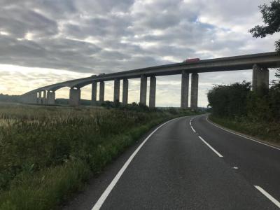
Orwell bridge This is a viewpoint 57 km from start 10m above sea level 3hrs59 at 14.2kmh Looking east The bridge really is a sight to behold.
-
Cattawade crossing This is a viewpoint 71 km from start 4m above sea level 5hrs03 at 14.1kmh Nice view across the Stour estuary here. Bit of a busy and narrow road, but there is a cycle path if you prefer.

-
Manningtree This is a town/village 74 km from start 3m above sea level 5hrs11 at 14.2kmh Lots of shops and cafes here!
-
Thorpe-le-Soken This is a town/village 89 km from start 22m above sea level 6hrs19 at 14.1kmh
Download: Route card
Packages:
