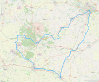
East Anglian Off the Rails 200k
Located in United Kingdom
Norwich - Diss - Stowmarket - Elmswell - Thurston - Bury St Edmunds - Lakenheath - Brandon - Thetford - East Harling - Eccles - Attleborough - Spooner Row - Wymondham - Norwich
Start point: Norwich railway station (52.6269679,1.3043811)
Total distance: 202 kms
Surface type: 100% road
Traffic levels: 72% Quiet roads 28% Busy / main roads
202km long 1159 metres of climbing 14hrs06 at 14.3kmh-
Diss railway station This is a transport hub 39 km from start 24m above sea level 2hrs43 at 14.2kmh

-
Stowmarket railway station This is a transport hub 64 km from start 33m above sea level 4hrs30 at 14.3kmh

-
Elmswell railway station This is a transport hub 74 km from start 64m above sea level 5hrs11 at 14.2kmh

-
Thurston railway station This is a transport hub 82 km from start 51m above sea level 5hrs45 at 14.2kmh

-
Bury St Edmunds railway station This is a transport hub 90 km from start 32m above sea level 6hrs19 at 14.2kmh

-
Lakenheath railway station This is a transport hub 121 km from start 3m above sea level 8hrs25 at 14.3kmh

-
Brandon railway station This is a transport hub 129 km from start 9m above sea level 8hrs58 at 14.3kmh

-
Thetford railway station This is a transport hub 140 km from start 13m above sea level 9hrs46 at 14.3kmh

-
East Harling railway station This is a transport hub 158 km from start 28m above sea level 11hrs00 at 14.3kmh

-
Eccles railway station This is a transport hub 166 km from start 27m above sea level 11hrs35 at 14.3kmh

-
Attleborough railway station This is a transport hub 172 km from start 39m above sea level 12hrs01 at 14.3kmh

-
Spooner Row railway station This is a transport hub 179 km from start 61m above sea level 12hrs28 at 14.3kmh

-
Wymondham railway station This is a transport hub 185 km from start 35m above sea level 12hrs55 at 14.3kmh

Download: Route card
Packages:
 Home
Cycling
Regions
Packages
Routes
Dot-watcher
Login
Sign up

