The Norfolk Globe Trotter (old)
Located in United Kingdom
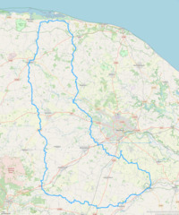
A clockwise tour of Norfolk, between the Waveney Valley and the North Norfolk coast. Starts and finishes in Stoke Holy Cross.
Surface type: 100% road
Traffic levels: 90% Quiet roads 10% Busy / main roads
212km long 830 metres of climbing 14hrs36 at 14.5kmh-
Ditchingham This is a town/village 18 km from start 19m above sea level 1hrs12 at 14.7kmh

-
Dickleburgh This is a town/village 42 km from start 38m above sea level 2hrs51 at 14.7kmh

-
East Harling This is a town/village 64 km from start 36m above sea level 4hrs23 at 14.7kmh

-
Shipdham This is a town/village 90 km from start 65m above sea level 6hrs09 at 14.6kmh

-
Fakenham This is a town/village 117 km from start 41m above sea level 8hrs02 at 14.6kmh

-
Stiffkey This is a town/village 137 km from start 18m above sea level 9hrs21 at 14.6kmh

-
Lyng This is a town/village 175 km from start 32m above sea level 12hrs01 at 14.6kmh

-
Hethersett This is a town/village 195 km from start 43m above sea level 13hrs22 at 14.5kmh

Download: Route card
Packages:
 Home
Cycling
Regions
Packages
Routes
Dot-watcher
Login
Sign up

